There are three main types of faults—normal, strike-slip, and reverse. The forces applied on the brittle rock define the motion on the fault, which in turn defines the type of fault. Normal faults, found mainly on divergent plate boundaries, are caused by horizontal stresses that move the two blocks apart. Reverse faults, found mainly on convergent plate boundaries, are caused by horizontal compression that moves the two blocks closer together. Strike-slip faults, found mainly on transform plate boundaries, are caused by horizontal compression and tension stresses of similar magnitudes, resulting in lateral block motion.
Faults are not always easy to identify. The erosion and deposition of sediments actively shape the landscape, sometimes erasing the surface traces of active faults. Other faults are buried, and they don’t leave a noticeable trace on the earth’s surface. They’re called blind faults. This makes the mapping of active faults—where future earthquakes will occur—a very challenging task for geologists and geophysicists, especially in regions where tectonic activity rates are low due to slow plate motion or distributed fault zones.
Did you know?
Scientists are not yet able to predict where every future earthquake will occur because it is impossible to map all existing active faults.
Active faults are those that are known to have moved, or suspected to have moved, in the recent geological past, usually a few thousand years. The mapping of active faults is the subject of Neotectonics. Neotectonic maps are most relevant for the assessment of seismic hazards and are used to help determine the placement and building rules of large facilities like power plants.
When enough evidence exists, the activity of a fault can be measured by the velocity with which opposite blocks move in relation to one another. Values vary from less than 1 mm/year for the slow deforming regions to many cm/year for the most tectonically active areas.
If during an earthquake the active fault ruptures the surface of the earth, it will generate a surface offset, which we call a fault trace. This can be identified and measured on the field, and also on the ocean bottom using high resolution marine geophysics surveys that map the bathymetry.
The continued movement of active faults displaces rivers, builds reliefs, and creates other geographical features that can be seen from the air and even from satellites in space.
After a strong earthquake, geologists and geophysicists go into the field to check the fault trace and measure its length, slip and dip.
There are three main types of faults—normal, strike-slip, and reverse. The forces that are applied on the brittle rock define the motion on the fault, which in turn defines the type of fault. Normal faults, found mainly on divergent plate boundaries, are caused by horizontal stresses, moving the two blocks apart. Reverse faults, found mainly on convergent plate boundaries, are caused by horizontal compression, moving two blocks closer together. Strike-slip faults, found mainly on transform plate boundaries, are caused by horizontal compression and tension stresses of similar magnitudes, moving blocks laterally.
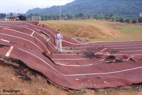
If the active fault ruptures the surface of the earth, it will generate a fault trace. The image shows the fault rupture of the Chi Chi earthquake, Taiwan, in 1999.
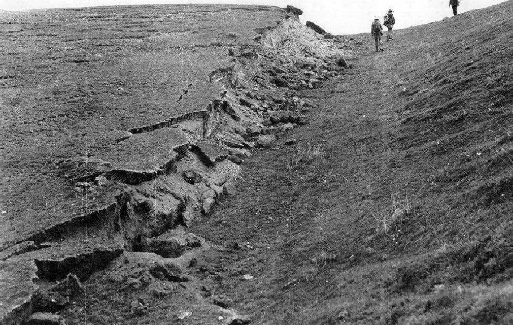
The 1988 Spitak earthquake, with a magnitude of M 6.8, took the life of thousands of people and caused widespread devastation in Armenia. It also ruptured the surface as shown in the figure.
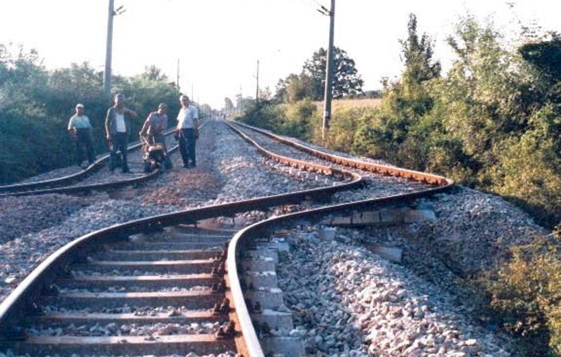
The August 1999 Izmit earthquake, in Turkey, was caused by the rupture on a strike-slip fault. It caused a large lateral movement between the two sides of the fault clearly shown by the rails.
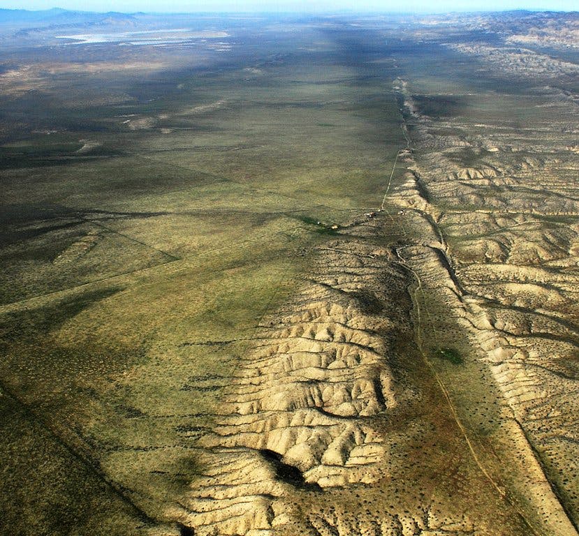
The continued movement of active faults displaces rivers, builds reliefs, and creates geographical features that can be seen from the air and even from satellites in space. The San Andreas fault trace shown in the figure is a good example.
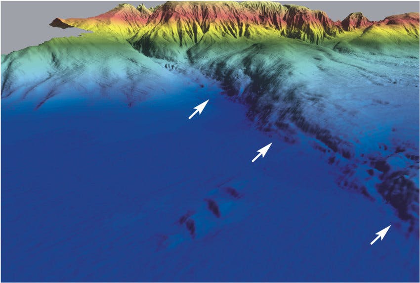
The continued movement of active faults also creates reliefs on the sea bottom that are disclosed by high-resolution bathymetric surveys. The arrows show the ocean bottom fault trace of the Horseshoe Abyssal Plain Fault (SW Portugal mainland), which has a length over 100 km and shows a vertical displacement higher than 1000 m at places. It is one of the faults that has been suggested to be the source of the 1755 earthquake and tsunami.
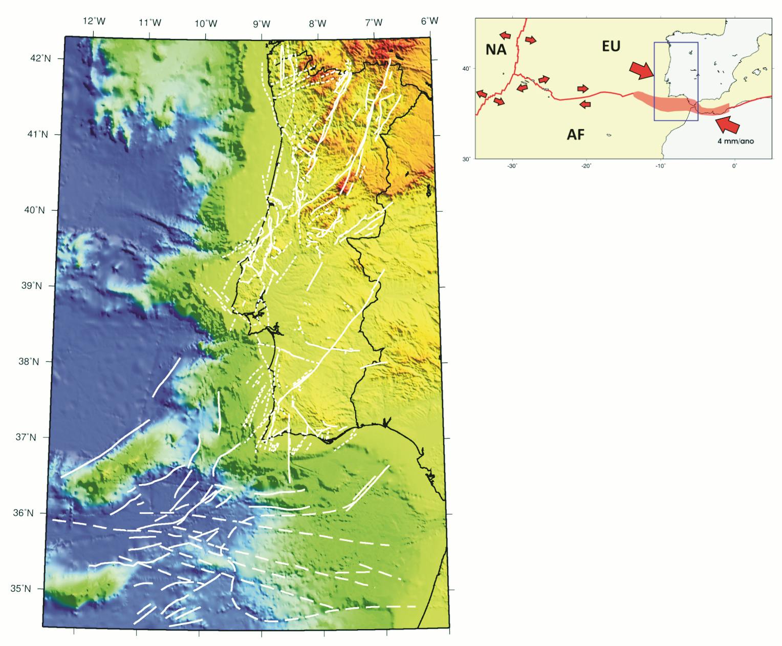
Map of active (full lines) and probable active (dashed lines) faults identified in Portugal and the surrounding oceanic domain. On land, fault activity is very low, with rates under 0.5 mm/year. The offshore fault activity rates are largely unknown.
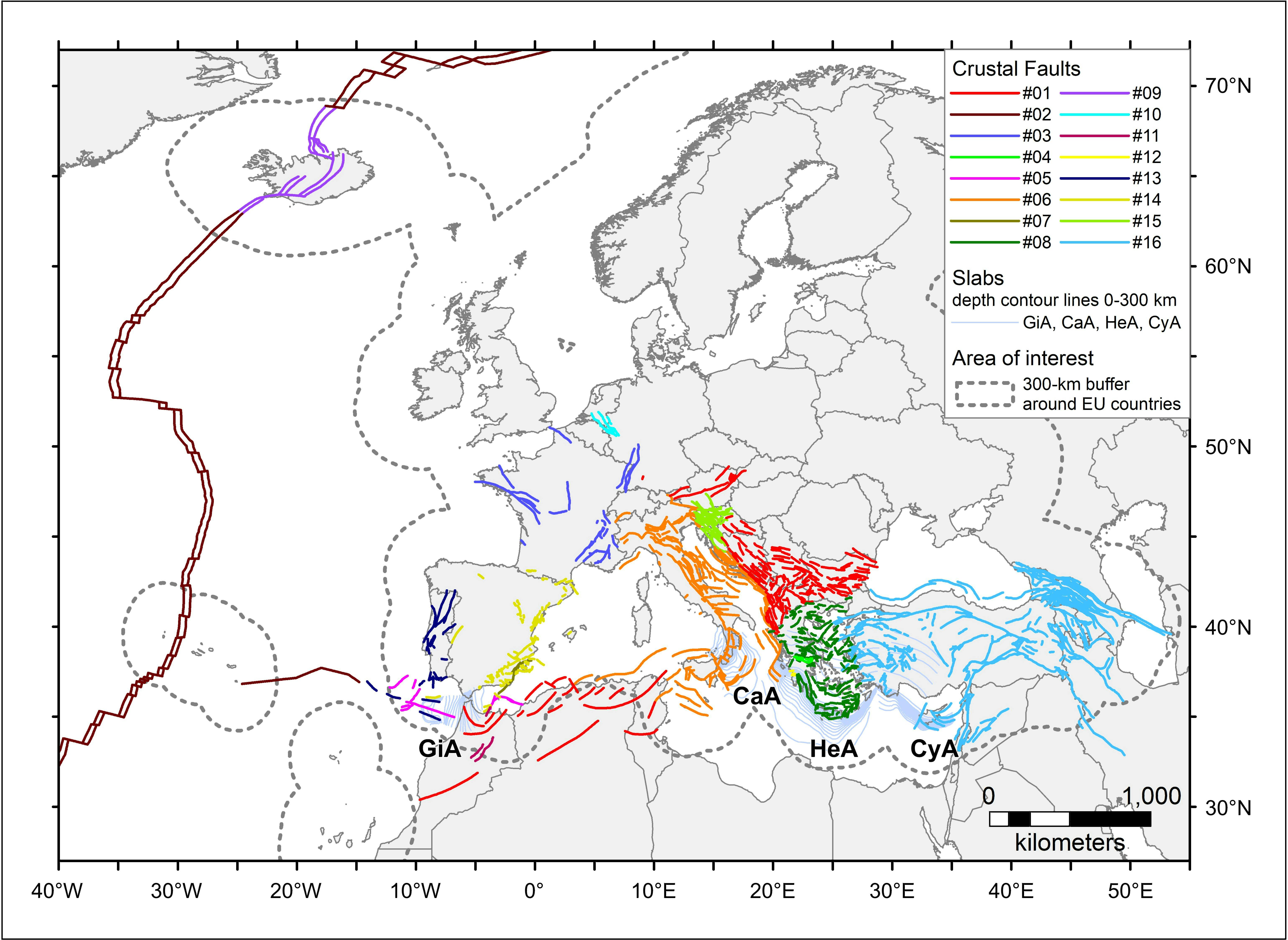
European Fault-Source Model 2020 (EFSM20) of seismogenic faults in Europe, displaying faults where earthquakes may originate in the near future.
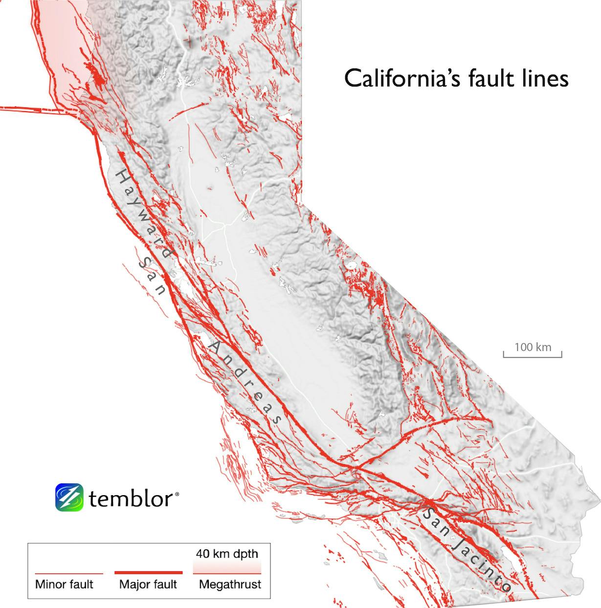
Active faults in California, USA.
Continue Exploring
Bibliography
Grotzinger, J. & Jordan, T. H. (2020). Understanding Earth, 8th ed. MacMillan.
Robert S. Yeats, Kerry Sieh, and Clarence R.Allen, The Geology of Earthquakes Oxford University Press, New York, 1997.
Instituto Dom Luiz
Seismofaults.eu, https://www.seismofaults.eu/efsm20